
Customer: Tennis Canterbury Region
Project Summary: Geospatial Analysis
To determine which clubs could best deliver the 'Tennis in Schools' programme to participating schools.
Challenge: Objective realignment of coaching services to schools
In the early days of the 'Tennis in Schools' programme, when there were only small numbers of participating schools and clubs, the assignment of club coaches to schools was informal and subjective. This approach often did not deliver the ideal outcome of generating interest amongst students and translating that interest into junior participation at the local tennis club.
As the programme went into full swing, the problems generated by this approach became more acute. Tennis Canterbury Region faced the overwhelming task of aligning the 100+ primary schools participating in the programme with the 23 different clubs in Christchurch.
The challenge for Vicinity Solutions was to justify the alignment of each school to a club in a way that was fair and transparent to both the clubs and the tennis professionals providing the coaching.
"Vicinity Solutions came up with a way to fairly distribute schools to tennis clubs in a way that will promote and encourage growth in our sport by taking a very strategic and well thought out approach.
I feel that without the guidance of Bryan Clarke and his team at Vicinity Solutions our 'Tennis in Schools' programme would not be the success it is today"
Hamish Cain
Club Development Manager
Solution: Using census data to determine school and club catchments and calculate which club best serviced the needs of each school
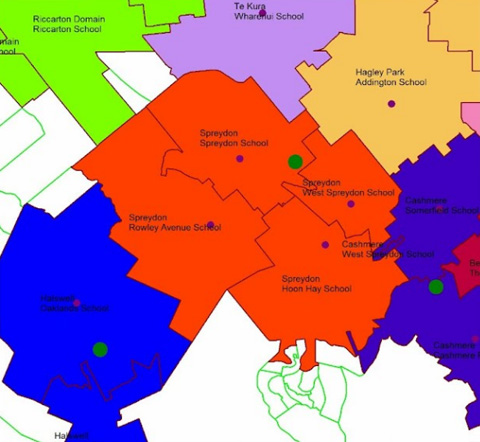
Clubs were filtered for those that provide junior tennis. Statistics meshblocks were assigned to the nearest club within 2.25 km of each club and amalgamated to create adjoining club catchments.
Schools were filtered for those that are state primary schools. Statistics meshblocks were assigned to the nearest school within 1.5 km of each club and amalgamated to create adjoining school catchments.
School and club catchments were spatially intersected, then aggregated for each school to calculate which club contained the largest population of each school catchment.
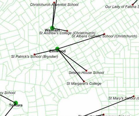
Unlike state schools, the catchments of private schools often overlap so a different approach was needed.
Schools were associated with junior tennis clubs that were within 4 km.
The distance between the school and each associated club was calculated and then aggregated for each school to calculate which club was nearest.
Business Benefit: Transparency and better decisions
Because the analysis was sound, fair, and easily justifiable, the results were readily accepted by the tennis community. It means that in future, Tennis Canterbury Region will be able to more easily and more accurately assess the success of the programme being delivered.
Tennis Canterbury Region is now aware of the strategic benefits that using geospatial data can bring to understanding and optimising their business of delivering tennis in Canterbury.
Download this case study
Tennis Canterbury Region case study (1.3MB PDF)